
These articles have been handpicked from the Society’s Newsletter and Journal.
The Visscher Panorama
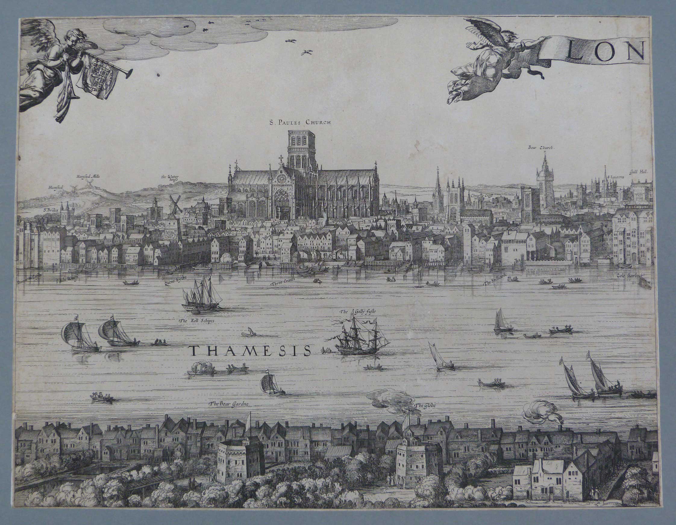
It is a happy coincidence that in the year when two later panoramas are being prepared for publication by the London Topographical Society (LTS), it is also possible to celebrate the conservation, with funding from the LTS, of one of the most famous earlier examples owned by London Metropolitan Archives (LMA). In this article, Jeremy Smith, Assistant Librarian of the LMA considers its changing status, and Caroline De Stefani, Conservation Studio Manager of LMA, writes about its repair and repackaging. A survey of the Visscher panorama in the context of London historical writing is in preparation for a future volume of the “London Topographical Record”.
The Visscher panorama is an engraving by Claes Jansz. Visscher first published in Amsterdam around 1616 with the title “Londinum Florentissima Britanniae Urbs Toto Orbe Celeberrimum Emporiumque”. It is one of the most iconic images of medieval London; a low-rise cityscape dominated by the spires and steeples of its churches. Published in the year of Shakespeare’s death, Visscher’s engraving is one of the few visual records of London before much of it was destroyed in the Great Fire of 1666.
London Metropolitan Archives holds two copies of the Visscher panorama. In 2016 one copy (ref. SC/GL/PR/LBV/p7494086) was displayed at the Guildhall Art Gallery alongside artist Robin Reynolds’s panorama of today’s metropolis.
Views of Visscher
Robin Reynolds’s revelatory revisiting of Visscher’s iconic London view, marked its 400th anniversary by drawing a dazzling new version (1) and in doing so prompts thoughts on the status of the original image, and how attitudes to it have changed.
Today ‘Visscher’ (only the one word is needed) is one of the best known and certainly most frequently reproduced depictions of late medieval London. It is an image, an almost unconscious or subliminal one, carried in the minds of all London historians, and those interested in the past of the City. But it was only in the later twentieth century that it reached this status and managed to shake free of its earlier more equivocal position. It was a work purporting to depict London, but originating entirely from a desk in Amsterdam. With no clear evidence of a ‘research trip’, or any obvious stylistic references being traceable to contemporary published works, its status has understandably caused suspicion.
Early historians of London ignored Visscher’s view. This is not surprising since they ignored all graphic works in favour of the supposed authority of the document. Later, especially in the nineteenth century, when graphic works slowly enter the literature of London history, Visscher makes isolated appearances. This is normally accompanied by awed references to its rarity but with little or no analysis of content. Bernard Adams (2) cites a prominent example in Robert Wilkinson’s successful Londina Illustrata of 1816 where the plates consist of ‘uncritically presented and topographically useless details enlarged from the long views of Visscher and Hollar’.
The evidential usefulness of the panorama was, at much the same time, recognised and utilised by J.T. Smith – but he was an historian with an unusually open mind to evidence, especially graphic evidence. For others, the panorama was to be held at arm’s length as an appealing novelty, tolerable for its attractiveness. Writing in The London Topographical Record in 1904 T. Fairman Ordish, in what is probably the first text concentrating on the panorama (the occasion being the publication of the LTS’s four-sheet facsimile in 1883-5) commented as follows: “The Visscher panorama is so attractive as a picture that we feel no surprise when we find that it was frequently reprinted”.
He refers of course to the multiple copies and re-engravings of Visscher’s panorama which quickly followed its first publication and included a version published in Venice in 1629. Ordish will also have been aware of the Victorian facsimile editions of the view, without a word of commentary and seemingly produced with little intention of satisfying the historian, but of providing decoration for many an office or tavern wall in the City. (3)
The responsibility for the rehabilitation of Visscher’s view is largely down to William Shakespeare – or at least indirectly. Controversy about the precise positioning of a plaque in Southwark to mark the site that would have been occupied by the Globe Theatre caused officials of the London County Council (LCC) to take up serious archival research. A number of publications followed including that by W.W. Braine’s The Site of the Globe Playhouse published in association with the LCC in 1924. This and other texts provided close contextual reading of Visscher’s view, the fulfilment of their work, in a way, being John Orrell’s The Quest for Shakespeare’s Globe in which Visscher is presented as one of the most significant documentary sources for the topography of ‘Shakespearean’ Bankside – and in a sense for the outstandingly popular townscape that so many people enjoy there today.
Visscher, by the mid-twentieth century, had, at last, proved himself useful to historians, and was then carried forward in the wave of popular, very well-illustrated London history books that proliferated in the 1970s and 80s (4); and again by the massive tide of historical television documentary of the past two decades.
Jeremy Smith
The conservation of the Visscher Panorama
The copy of the Visscher panorama which was the subject of the conservation project (ref. LMA SC/PD/XX/01/04) is by far the better impression. The panorama is made of four panels of handmade paper measuring 535 x 422 mm. The quality of the etching is very good, the black printing ink lines are very sharp and the chiaro/scuro areas are well defined.
The Condition of the print before treatment
Although the overall condition of the print was generally good, inappropriate storage and extensive handling in the past had caused damage to the paper which now presented ingrained surface dirt and long tears along the folds. The panels had been repaired extensively in the past and lined on the back with heavy white handmade paper cut to the size of the print. The backing paper of one panel had larger margins and therefore made the entire panel bigger than the other three. The panels were stiff and discoloured along the repairs probably due to the deterioration of the adhesive used. Some tears had been mended, but the edges were not aligned accurately. Other tears had not being joined, only stabilised leaving a gap between the edges. Other losses around the print were present especially along the edges. The infill repairs had been made with western handmade paper that had caused distortion and fraction of the original paper. Some repairs had been retouched to complete the missing etching. Other infills were made with paper that replicated the original print.
In this state the panels could not be accessed and displayed without the risk of increasing the distortion and tears.
Conservation treatments
LMA’s paper conservator Hilary Ordman was in charge of the conservation treatment of this print. All four panels were thoroughly dry cleaned by means of a soft brush on the printed side and a vulcanised latex sponge on the edges and on the back of the print. All the different media were tested against fugitivity with distilled water. As all the inks proved to be stable it was, therefore, possible to wash the print to remove all the soluble acidity and the stains. The print was washed in three consecutive cold water baths until the water was clean.
While the panels were still wet the paper lining of the back was removed. It was decided to remove also the old repairs that were causing fractures on the print. All the other repairs that were stable and made using a paper similar to the original print, and the infills where hand drawing had been made to replicate the missing images, were kept. The panels were left to dry under lightweight between thick blotting paper.
The paper repairs and infills were done first on the back of the print using Japanese paper of the appropriate thickness and wheat starch paste. The missing areas on the front of the print were then repaired using Japanese paper toned with watercolours to match the colour of the original paper. All four panels were interleaved with acid-free tissue and housed in an archival four flap folder.
Following conservation, the panorama has been digitised and made available on LMA’s Collage – The London Picture Archive alongside the other copy.
Hilary very much enjoyed working on this project not only owing to its aesthetic value, but also because it allowed her to discover and discuss details of the history of the print with curatorial staff in the Graphic Collections team.
LMA is grateful to the LTS for its generous support of this project.
Caroline De Stefani
References
1. Shown at an exhibition Visscher Redrawn, at Guildhall Art Gallery, March to November 2016.
2. In London Illustrated (1983)
3. See Irene Scouloudi’s 1953 thesis Panoramic Views of London or A.Hind’s: Engraving in England (volume 2, 1955)
4. Few were without an illustration of Visscher, quite often on the cover: works such as London 2000 years of a City and Its People (1974), a model of its genre by Felix Barker and (former LTS Chairman) Peter Jackson
The Role of a Topographical Society
A paper read at a symposium on the role of Urban Museums held at the Museum of London in April 1993 by Simon Morris who is currently the Society’s Honorary Publications Secretary.
In this paper I seek to address this issue obliquely — not by discussing the role of a museum, but by considering the contribution to urban studies which can be made by a topographical society. A museum, we can safely assume, is a most appropriate medium for these studies. However, I believe it will be accepted that it is by no means the sole suitable medium, and I hope to demonstrate that a body such as a topographical society has a worthwhile contribution to make. I take for illustrative purposes the activities of the London Topographical Society, although I hope to extrapolate points of general interest and application from this discussion, rather than merely to narrate the London Topographical Society’s functions.
A good starting place is to consider the points of distinction between an urban museum and a topographical society. A museum is a building for the exhibition of artistic or scientific objects; taken literally, a home of the muses. A topographical society differs in a number of respects. First, and most important, it is devoted to studying the features of a particular location. This is its paramount function to which all other activities are subsidiary adjuncts. It does not collect, conserve or exhibit. Instead it studies, publishes and lectures. Secondly, in distinction to a museum, it defines itself by relation to an activity rather than a permanent place of display. This, of course, is by no means a necessary pre-condition, but what a society unburdened with responsibility for premises or staff lacks in visibility or permanence, it gains in flexibility and accessibility. I will return to this theme.
I should make two preliminary points. First, there is no such thing as a standard topographical society; each will define its area of study, range of period and scope of activities. The London Topographical Society takes the physical development of London and environs in all ages; other societies may encompass a wider or narrower physical location, time-span or theme, for example restricting themselves to transportation, building or economic activity.
Secondly, the body in question need not be a society in the sense of a voluntary association of individuals. It can equally well be constituted in some other fashion. For example, the Museum of London contains extensive material concerning the growth of London; the University of London runs post-graduate degree courses on London topography and urban history generally, while the Royal Commission on Historic Monuments (a government body) publishes the learned Survey of London, a detailed topographic exposition of London which progresses on a district-by-district basis. Each of these bodies contributes to the study of the topography of London.
A topographical society, though, is rather different. As a voluntary association of individuals it can, like any local history society, define its objectives free from statutory obligations and the vicissitudes of municipal funding. It can engage in a range of activities of its choosing answerable only to its members and constrained only by the size of their subscriptions. As a free enterprise player in an arena denominated by state-funded bodies, a topographical society possesses the significant advantages of speed of response and flexibility of approach.
What, then, can a topographical society do? There is no fixed range of activities, but it is suggested that the core functions of such a society are publishing, lecturing and visiting. An urban museum can and will do all of these. However, with so many other responsibilities these tasks may not always receive the attention and resources that they deserve.
The first of these functions — publishing — is perhaps the area where a topographical society can make the most significant contribution and, incidentally, that upon which the London Topographical Society concentrates. Publishing material relating to urban history is an expensive and time- consuming business. Each work requires painstaking research, each illustration has to be identified, the publication carefully edited and the printer minutely supervised. The publications of a topographical society may be ones that would not otherwise see the light of day. The cost of production, the time commitment involved and the uncertainty of a market may combine to dissuade a museum from undertaking such work, unless perhaps in conjunction with a major exhibition, and a commercial publisher from even considering the venture. A topographical society, though, by using the unpaid labour of its officers and obtaining funding both from the subscription of its members and proceeds from the sale of other publications, can undertake such ventures in the assurance that it will not incur a financial loss.
It will be helpful to illustrate the kind of material that a topographical society can publish by mentioning some recent publications of the London Topographical Society, of which a full list appears in the annexed catalogue. These include a portfolio containing full-size reproductions of the Ordnance Survey Drawings of the London area in 1800; Good and Proper Materials, a study of London construction materials; The London Surveys of Ralph Treswell, an Elizabethan surveyor; and a reproduction with notes of Booth’s Poverty and Wealth Maps of late Victorian London. It is submitted — with all due modesty — that these are scholarly and valuable contributions to the study of London topography and ones which, in the absence of the London Topographical Society, would not have been published.
It is important to explain how the London Topographical Society publishes works of such quality. It has some 1,000 members each paying an annual subscription of £20. This entitles the member to receive without further charge the year’s publication, such as that described above. The London Topographical Society also sells its publications to the general public, to booksellers and to institutions. Its income from this source is a further £10,000 per annum. Its annual income of £30,000 pays for the publications, each of which ranges in cost from £10,000 to £30,000, for despatch of the publications by post and general administration. By judicious management of costs and timing of publications (generally one or two per annum, issued in mid-summer) the London Topographical Society balances its books and sets aside a small surplus for future projects. The Society enjoys two particular advantages. First, as a charity, it pays no tax on its income. Secondly, no one (except the printer) expects to be paid for their services.
The members are predominantly individuals living in the London area, but there are over 100 institutional members such as museums and libraries throughout the world. A society such as the London Topographical Society is dependent upon a relatively stable membership to fund its activities. This it maintains, albeit with an annual turnover of some 5 per cent, by issuing a prospectus and also as a result of receiving regular reviews of its publications in the national and specialist press.
Lecturing and visiting are two further functions that fall within the purview of a topographical society. That the London Topographical Society does neither illustrates the diversity — if not idiosyncrasy — of voluntary societies. An extensive series of lectures on various aspects of London topography is offered by the London and Middlesex Archaeological Society, the Greater London Industrial Archaeological Society and other local history societies. A wide range of visits is conducted by the London Society.
Another distinct feature of a topographical society is accessibility. As an informal body, a topographical society offers the opportunity for a non-specialist to become involved in urban studies. The lawyer, banker or author who studies urban topography as a recreation finds a platform for his lectures and a publisher for his treatise. Someone who is a participant rather than a contributor can attend the lecture or visit, and enjoy the publication. In both cases the circle of those who participate in urban studies is broadened, attracting those who might otherwise have little or no involvement in this area.
One further advantage gained from the constitution of a topographical society is that it can be very flexible. The lead time required for a publication can be as little as three months, which enables the London Topographical Society to react quickly to the offer of a manuscript, or a suggestion to publish some other work. Moreover, operating on a non-commercial basis, it can lavish time upon a publication.
In all of these ways a topographical society can build upon and augment the activities of an urban museum. The relationship, though, goes further than this, and it can be one of close co-operation and not just symbiosis. At its simplest a topographical society may hold its meetings in a museum’s lecture theatre, sell its publications through the museum’s bookshop and distribute its leaflets in the museum’s foyer. The relationship, though, can be deeper and more significant. A topographical society may rely on the local museum’s libraries, urban archaeologists and learned bodies for guidance on choice of publications, the provision of lecturers and, most important of all, the assurance of quality. In order to make a worthwhile contribution to urban studies, the topographical society’s publications must be scholarly, its lectures informed and its visits stimulating. The connections between a topographical society and an urban museum, both at institutional and personal levels, help ensure this is achieved.
Taking again the London Topographical Society as an example, it enjoys a close working relationship with the Museum of London and frequently draws upon its professional resources. Several museum officers are members of its governing council, contributing their skills and experience to the Society’s publications programme. The Society may publish works by members of the Museum of London’s staff, while on other occasions the Museum itself, or other historic libraries in London, may supply an original work for reproduction, or provide the prospective author with facilities and materials for pre-publication research.
A topographical society can certainly benefit from working with an urban museum and the converse is also true. A society which offers a programme of lectures on urban history and topography, or a series of visits to historic sites in the locality, will both provide a platform for the museum staff to address a wider audience, and also provide activities which may complement the museum’s own exhibitions. Furthermore, a Society’s activities can result in useful finds for a museum. Artefacts may be unearthed and sources of valuable oral history introduced to it.
The urban museum and the topographical society working together in their chosen spheres can each make a valuable contribution to the work of the other. The museum provides a focus for the society; the society undertakes activities which are ancillary to the museum’s and, by drawing on a diverse membership base, increases those who benefit from the museum’s services. So is the museum a fixed reliquary, and a topographical society an ephemeral contributor of occasional learned publications? I hope I have shown not.
The London Topographical Society: A Brief Account
This article, written by the Hon. Vice-Chairman Stephen Marks FSA when Hon. Secretary of the Society, appeared in Volume 24 of the London Topographical Record published in 1980. Stephen died in May 2020.
Among the plethora of societies which are concerned with the history of London, many, especially the local societies, have been formed in recent years, but a few have their origin in the last century. The earliest of these, the London and Middlesex Archaeological Society, began in 1855 and when that society was no more than twenty-five years old our own was founded.
The original suggestion was made in Notes and Queries in 1873 by Major-General J. Baillie writing from India. He thought there should be a ‘Topographical Society as well as Geographical and Geological Societies, to perform the same office for art as they do for nature. There is,’ he continues, ‘an immense mass of unappropriated material which would naturally fall to it, such as plans and views of towns, parishes and estates, plans of railways, etc., and engineering projects, views of the same at different periods and last, not least, photographs. Now that we have arrived at permanence in printing, such an association, indeed, should retain a permanent photographical establishment to reproduce rare plans and views that may come into their possession, and supply copies of anything that might be called for at a minimum rate of reproduction’.
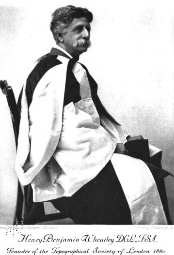
His note brought some response but no action. In 1879 he wrote again to the same journal and prompted a detailed reply from Henry B. Wheatley. Wheatley, born in 1838 and energetic in the cause of London history right up to his death in 1917, was, among other things, Secretary of the Royal Society, founder of the Index Society and Secretary of the Early English Text Society; he produced a standard edition of Pepys and other books but his most important work is the three-volume London Past and Present (1891), still the standard dictionary of London.
Wheatley proposed a society whose purview was restricted to London; this was certainly not what General Baillie had in mind. It could be either an antiquarian society – but this, Wheatley thought, would overlap with the existing London and Middlesex Archaeological Society – or it could be an association on a much wider basis. This he favoured: its ‘main object should be to collect in one focus all materials for the history of ancient and modern London, and to arrange these is such a way that they could be easily consulted …… Every Londoner with a guinea in his pocket ought to become a member.’
The seed was thus sown and Wheatley took the initiative in forming a society. Notes and Queries on 10 April 1880 briefly records that ‘in accordance with the suggestion General Baillie made in these columns, a Topographical Society of London is in the curse of formation. The following gentlemen have formed themselves into a provisional committee:- Major-General A. Stewart Allan, Major-General J. Baillie, Hyde Clarke, F.S.S., G. Laurence Gomme, F.S.A, Edward Solly, F.R.S., Cornelius Walford, F.S.S., Henry B. Wheatley, F.S.A., H. Trueman Wood, B.A.’ The first meeting, at which four of these gentlemen, including Wheatley and Baillie, were present, is recorded on an undated slip at the front of the first minute book of the Society.
The provisional committee gained the favour of the Lord Mayor towards the proposed society and were able to hold their inaugural meeting at the Mansion House on 28 October 1880. Extracts from a prospectus, read at the meeting, show the considerable ambitions of the committee: of the numerous topics for the Society the most prominent were considered to be the collection of books, etc. on London topography, the collection of documents and deed, the etymology of London place name, the preparation of maps and plans showing buildings, etc. at different periods, records of buildings before demolition, a bibliography of London topography, an index of drawings, etc. in collections, and the publication of copies of old London engravings and unpublished drawings and of documents relating to London. There were to be an annual report and committees to watch over topographical changes and demolitions in several districts. In short, there were two broad visions of the work, collection and consultation, and publication. It was recognized, however, that there were limits to what the Society could do to begin with and priority was accorded to the latter, i.e. the various aspects of publication, and to the district committees.
The inaugural meeting approved the formation of the Society with the object as set out and gave authority for an organizing committee of twenty-nine persons, including T. Fairman Ordish as Honorary Secretary, to act till a council was appointed at the first Annual Meeting. Wheatley, the founder of the Society, became its Director and was to superintend the arrangement of publications.
The Society was not formed without opposition, however. Before the inaugural meeting the London and Middlesex Archaeological Society approached Wheatley with the suggestion that a topographical section of that Society should be formed instead. The Topographical Society’s provisional committee thought that there was no advantage in this, and that there would be a disadvantage in trying to raise an extra guinea for a section from existing members of a society. The London and Middlesex then asked the Lord Mayor to receive a deputation; he invited them to attend the inaugural meeting to which the joint secretaries replied on an open letter ‘… It is clearly out of the question that we, who think the proposed Society is (to say the least) unnecessary, should attend a meeting so called and so constituted. We once more renew our offer made to Mr Wheatley …. And we leave with your Lordship and the meeting the responsibility of rejecting it, and of adding another to the list of Societies which, by their multiplication, tend rather to hinder than promote the sciences they profess …’
However, a member of the Archaeological Society, Cornelius Walford, also a member of the new society’s Organizing Committee, thought that this was not the general feeling of the members of the former, a number of who had joined the Topographical Society. Walford rightly identified the Topographical Society’s work as ‘the reproduction of maps, drawings and charts of London … This work no other Society has attempted to accomplish’.
The provisional committee met altogether four times in 1880, thrice before the inaugural meeting in October. After the inaugural meeting there were 139 members and by November 1881, 166. The committee proposed an ambitious programme of publication for its first year, 1880/81, comprising part of Wyngaerde’s View, Braun and Hogenberg’s map, Norden’s 1593 map and a volume of extracts from State Papers, etc. relating to Elizabethan London. In the event the Society published Wyngaerde’s View on seven sheets for the first two years, Braun and Hogenberg for 1882/83 and Visscher’s 4-sheet view for the next two years. In the fifth year there were less than 50 members and publications then ceased.
Wheatley and Ordish were between them the active members of the committee but were so busy with their own affairs that there were, if the record in the minute book is correct, meetings only in 1881 (once) and 1885 (twice) after the promising start of 1880. The Society languished with rapidly diminishing subscription income and must have been thought defunct, but in 1896 Ordish called a meeting ‘to explain the cessation of the work of the Society’ and ‘to consider the advisability of re-starting the Society’.
The old Society had been called the Topographical Society of London: restarted it became the London Topographical Society, with the same objects and many of the same people involved. Wheatley and Ordish, Director and Honorary Secretary of the Topographical Society, G. Laurence Gomme (later Sir Laurence Gomme, Clerk to the London County Council) and two others of the former Council were on the new Organizing Committee. Among the new members of the committee were Sir Walter Besant, Edwin Freshfield, Philip Norman and J.P. Emslie. An inaugural meeting of the new society was considered but not held because it was in continuation of the old. The Organizing Committee held seven meetings between 1896 and 1899. Regular publication began in 1898 and the first formally constituted meeting of the Council of the new society was held in 1899.
Since that time there has been no significant interruption in the Society’s work. This has always been limited to publication, a purpose reaffirmed from time to time in the minute books. On occasion excursions out of the publishing field have been suggested but the Society has always resolutely refused to so anything that was not ancillary to the publishing function. Inevitably there have been special occasions for some other activity, such as an exhibition and conversazione at Drapers’ Hall in 1905 and another exhibition in 1947 at Guildhall, and a special committee to consider what could be done about the dispersal of the splendid Gardner Collection of London views, letters written to petition the Prime Minister to set up a commission on ancient and historic buildings (the Royal Commission on Historical Monuments) and to petition the Benchers of Lincoln’s Inn not to destroy their gatehouse, but too often the Society has decided not to support a particular worthy cause because it was outside the Society’s terms of reference. Moreover, there are now numerous bodies, not least the Royal Commission referred to, created since 1880 and performing many of the tasks which the Society set itself at the onset.
The old society possessed money and property in the form of publications of considerable value. In 1898 the new society took over the stock from the printers who had looked after them and, because of certain variations in the paper on which the Wyngaerde view was printed, an expert was called in to advise. The expert was Emery Walker; he became the Society’s technical adviser on all important questions concerning the reproduction of maps and drawings, and personally supervised their execution by his own firm. Walker was one of those who with William Morris were responsible for the renaissance of fine printing and book production and he had in 1896, shortly before his avocation with the London Topographical Society, started the Doves Press with T.J. Cobden-Sanderson: the Society was extremely fortunate to have the benefit of his interest and skill. His work for the Society was generally executed by collotype, undoubtably the most suitable process for continuous tome reproduction but one requiring a very high degree of care and more expensive than other processes.
The Society has always had on its Council men and women whose names are household words in London studies. Many have made a great contribution but none can match that of Walter H. Godfrey. His first contact with the Society was his unsuccessful application for the post of Secretary, then salaried. He was one of four applicants and came second in the assessment. He actually joined the Society in 1916 and was elected to the Council in1919, became Chairman and Editor in 1928 and held those offices till his retirement in 1960, a year before his death. As Editor he was responsible for eight volumes of the Record and for a large number of other publications and he kept the Society going during the Second World War almost single-handed with the issue of a publication every year except 1943. At the same time he was responsible for the publications of the London Survey Committee and for the establishment of the National Buildings Record.
The Society’s membership has never been large when one considers the enormous number of people who might be interested. In 1899 when it restarted it had 114 members; the number climbed steadily till in 1906 it reached 220, at which level, give or take a score, it remained till 1930. In 1913 warning noises were sounded by the Treasurer who advocated a policy retrenchment after three years of overspending, but mounting balances during the Great War indicate that the Society was well able to continue its existence although conditions were more difficult. It was after 1930, in the years of the depression, that numbers fell steadily till in 1938 there were 151 members, described as ‘very low’, and the the lowest ebb coincided with the blackest year of the war, when in 1942 there were only 111 paid-up members and only three people at the Annual General Meeting.
Fortunately Godfrey had prepared in advance a series of plans which he was able to issue for 1938, 1939, 1940 and 1941; he brought out a volume of the Record in 1942 (vol. XVIII, the scarcest of all), and in 1943, on the reasonable assumption that there would be ‘few, if any, original members on the roll of the Society, the Society was able to save expense by offering a choice of past publications to its members. After the war membership began to pick up, with a boost from the publicity of the 1947 exhibition already mentioned. The increase from 184 in 1947 was slow and irregular till 1960 when there were still only 208 members, but from then the numbers increased much more rapidly till today they stand at almost 500, of whom 80 are overseas with a large proportion in America.
For ninety years the subscription remained at the original guinea; in 1971 it was rounded up to £1.10 to simplify calculations in the new decimal currency. The first substantial increase, to £2.50, came in 1974, and contrary to fears very few members were lost as a result of the increase. Now, in the centenary year, the annual subscription is £5.
In earlier years the Society’s publications were strictly reserved for members and could not be purchased by the public. The Society was thus outside the provisions of the Copyright Act and the British Museum was obliged to acquire the publications by purchase. The Society still maintained that the same situation applied in 1917 when the National Library of Wales asked for publications but in fact well before that Stanford’s, as the Society’s agents, were selling to the public at prices which were at least 50% over members’ prices. At what point the Society changed its attitude is not clear.
The numbers printed were related to a great extent to the membership. Print orders were often for 250 copies. The plates would be available for renting, but there is not much evidence in the minute books of their use; perhaps it was a routine matter to re-order without reference to the Council. Since 1959, however, it has been the Society’s policy to print much larger numbers, typically 1000 copies, of which between 300 and 500 only have been needed for distribution to members, backed up by an increased drive to sell past publications both to the public and to members. Whereas previously the sales of publications were a useful but usually not significant contribution to the Society’s income, since 1960 sales have exceeded subscription income in 13 out of 19 years and have made it possible to undertake more ambitious work such as Milne’s Land Use Map of London and Environs in 1800 (publication No. 118/119), to reprint out-of-print items, and to produce other publications extra to the subscription issue.
In this period the Society has also been greatly helped by receiving the residual funds, about £750, of the Survey of London Committee, to whom our reproduction of Horwood (No. 106) is dedicated, and by the very substantial gift of Miss Helen Barlow which enabled the Society to publish Mills & Oliver (Nos. 97-99, 101 and 103) and her legacy in 1976. The Society thus has now established a strong, almost self-priming, financial basis for its publishing work.
A perusal of the Society’s complete list of 124 publications, printed elsewhere in this volume, will show their wide range. The majority are facsimile reproductions, mainly of sheet material, envisaged by General Baillie in 1873 as an important facet of a topographical society’s work. There is also a substantial body of research, in some cases accompanying the sheets, but mostly printed in the London Topographical Record, the Society’s journal, and other volumes. The Record started life in 1901 as the Annual Record but immediately a year was missed and its name was changed; the last eight volumes have appeared at intervals of five to eight years culminating with the present volume XXIV. Other books contain research which either because of its length or because of the nature of its illustrations is unsuitable for the Record; several of these have followed a larger format, as a monograph series, starting with the author’s Map of Mid-sixteenth Century London (No. 100) in 1964. Of less permanent value, but of interest nevertheless, with notices to members, reviews and short articles, is the London Topographical News, a newsletter sent out twice a year since 1975.
Inevitably, many of the most important items, published in the early years, are now out of print. The Society has been aware of the need to make them available again and has reissued two Hollar works (nos. 104 and 112), but the pressure has been much relieved by the increasing activity of other publishers.
In 1900 Lord Welby, the new society’s President, said ‘The Society will then gradually create an illustrated History of London which its citizens can acquire for themselves at moderate prices’. Though less all embracing than Wheatley’s first thought of collecting all materials for the history of London in one focus, Lord Welby’s claim, no doubt reflecting the confidence of the Society, seems too sweeping to modern minds. In its current leaflet the Society’s purpose is ‘to assist the study and appreciation of London’s history and topography by making available facsimiles of maps, plans views, and by publishing research’. That purpose, we might be forgiven for thinking, the Society has truly served in a hundred years of publishing and will do so for another century.
Principal sources
- Minute books of the Society: Vol. 1, 1880-1901; 3, 1908-10; 4, 1910-15; 5, 1915-30; 6, 1931-65; 7, 1965 onwards. The minutes for 1901-7 are missing.
- Report of the Inaugural Meeting of the Topographical Society of London held at the Mansion House, 28 October 1880.
- General Report of the late Topographical Society of London [1896], reprinted as an appendix to Annual Report 1899.
- Annual Reports and Accounts in the London Topographical Record and London Topographical News.
- Notes & Queries, 4th series XII (1873), 186, 5th series XII (1879) 424 AND 469, 6TH series 1 (1880), 40 and 308.
Walter Godfrey – The Society’s Chairman & Honorary Editor 1928-1960

Volume XXII of the Society’s currently five-yearly ‘London Topographical Record’, published in 1965, carries an obituary by Sir John Summerson on Walter Hindes Godfrey CBE who had died in 1961. Architect and antiquarian, between 1941 and 1960 he was the first Director and the inspiration behind the foundation of the National Buildings Record, the basis of today’s English Heritage Archive. Walter Godfrey’s leadership, as Chairman and Honorary Editor of the London Topographical Society from 1928 until 1960, almost single-handedly kept the Society afloat during the supremely difficult period of the Second World War when he managed to produce a publication for every year except 1943.
The amazing list of his published works, compiled in the same volume of the Society’s Record by Majorie B. Honeybourne, who succeeded him as editor, comprises 12 books, 13 pamphlets, 21 Sussex church guides, editorial control of 37 publications including six editions of the ‘London Topographical Record’, 146 general articles, 57 London articles, 234 Sussex articles, 50 reviews and 17 illustrations and plans.
Walter Hindes Godfrey was born in London on 2 August 1881 the eldest child of Walter Scott Godfrey, who at the time was conducting a small wine business. His mother was Gertrude Annie Rendall of Bristol. The elder Godfrey gave up his private business in 1882, joined another firm and then, in 1884, became manager to W.H. Chaplin and Co. of Mark Lane. He was a man of uncommon forcefulness and energy and, as his son described him, ‘self-centred and self-conscious to a degree almost unbelievable’. The first twenty-one years of Walter Godfrey’s life, as he has recorded them in the memoir written for his family, present the picture of a household dominated by the father’s ruthless idealism, first of a religious kind and later agnostic and socialist. In 1888, when Walter was seven, his father broke with his employer and resolved to become a minister of religion, entering C.H. Spurgeon’s Pastors’ College to qualify himself. This meant dispersing the family and Walter was sent to live with his grandmother at Borehamwood, near Elstree. In 1891 they were re-united in a house at Croydon and Walter was sent to Whitgift Middle School. He was there until the end of 1895 when he gained a scholarship to the Upper or Grammar School. Meanwhile, the pastorate which his father had undertaken at Croydon met with ill success, partly no doubt because of the increasing liberalism of his teaching, and he was constrained to return to the wine business. In 1896 he declared himself an agnostic. This in no way impaired his sense of mission or the hardships, including extravagantly early rising and vegetarianism, which he imposed on his family. He turned to the doctrines of Bernard Shaw, Ramsay Macdonald and Moncure Conway without remitting any of the crusading puritanism which his self-esteem demanded.
Walter Godfrey’s schooldays he records as busy and happy and he found plenty of interests to offset the rigours of his home life. He passed the London University matriculation examination in 1898 and, for a short spell, worked in the office of C.H. Chaplin and Co.where his father was employed. Then came an offer, which had been tentatively made two years earlier, from Mr James Williams, architect, of Victoria Street to take Godfrey into his office as an articled pupil. Williams had succeeded to the practice started by George Devey (1820-86), whose country houses and gardens in the Elizabethian manner are among the most distinguished achievements of mid-Victorianism. The offer was accepted and Godfrey’s pupilage lasted for two years, during which time he explored the medieval monuments of London and the surrounding country, measured at South Kensington and Westminster Abbey and attended evening classes at the Central School of Arts and Crafts, where Henry Ricardo was teaching. In December 1900 he left Williams and took employment in the architectural section of the London County Council.
In 1901, while still not 20, Godfrey published his first archaeological article in W.J. Hardy’s Home Counties Magazine; it was on the Whitgift Hospital in Croydon. In April of the same year he was elected a member of the Survey of London which C.R. Ashbee had founded in 1894 and whose object was the publication of monographs and parish surveys to record the ancient buildings of London, then unprotected by any kind of legislation. He was at once involved in preparation for the first of the Chelsea volumes – preparation which led to his authorship of all the four volumes which appeared between 1909 and 1927. In 1902 he attained his majority, on which occasion his father gave him a bicycle and, soon after, instructed him somewhat peremptorily to leave home and fend for himself. He took a furnished room at 8 Glebe Place, Chelsea, and in September rejoined the London County Council, which he had left for a short period.
Godfrey’s ideas at this time were very much those which his father had done his best to instill. They are reflected in a few short essays published in the Reformer and elsewhere. But ethical humanitarianism is a bleak garment for a young mind and Godfrey soon threw it off. He did so, with a sense of immense relief, under the influence of Emil Reich, the Professor of History at Birkbeck College, whose lectures he attended in 1904-6. Reich’s view of history ‘opened the doors of the prison house’ and showed the way to a more optimistic evaluation of the world and one which Godfrey, with his love of nature, eagerly accepted and always retained.
In May 1903 Godfrey finally left the London County Council and returned to the office where he had served his articles. Mr Williams had retired and his partner, Edmund Wratten, conducted the practice and took on Godfrey as an assistant under a two-year agreement. Before the term was out, however, Wratten had married Godfrey’s sister, Gertrude, and the two men had formed a business partnership as successors to James Williams, commencing practice in the old offices at Carteret Street, Queen Anne’s Gate, in the autumn of 1905.
The prospects of the partnership were not brilliant. With time on his hands for study Godfrey entered for the Royal Institute of British Architects’ Essay Medal. The set subject was ‘The Life and Work of a Great Victorian Architect’ and Godfrey chose Devey. He won the medal. It occurred to him that the essay might be expanded and that a round of visits to Devey’s country houses might serve the double purpose of gleaning information and introducing himself as Devey’s successor to their occupants. If the scheme brought no rush of work to the office it spread the partners’ reputation among a circle of wealthy and influential people.
In June 1907 Godfrey married Gertrude Warren, to whom he had been deeply attached since he was 19. The story of his first rejection, of Miss Warren’s engagement to another man and of the final outcome leading to an ideally happy marriage lasting for nearly fifty years, is touchingly told in the memoir. After a honeymoon at Les Andelys, the young couple settled in a cottage at Radlett.
Godfrey at this time was busy on illustrations, notably for Garner and Statton’s Domestic Architecture in England in the Tudor Period, published by Batsford in 1911. For this work he produced an elaborate elevation and perspective of the oriel window at Crosby Hall, Bishopsgate, then threatened with demolition. Simultaneously was he contributing an architectural study on the Hall to Philip Norman’s monograph on the building. This appeared in 1908 and aroused the interest of Professor Patrick Geddes of Edinburgh. Geddes asked Godfrey if he could rebuild the hall on a new site and the reply was that he could. The roof and the numbered stones had been accepted by the London County Council for re-erection at somebody else’s expense; and the Town and and Gown Association, with which Geddes was associated, were able to provide a plot of land in Chelsea, part of which had been built upon to provide the headquarters for the British Federation of University Women. Godfrey undertook to rebuild the hall for £7000, and eventually, after some very anxious moments, saved £120 on the contract. The hall was rebuilt in the course of 1909-10 and opened in the latter year by John Burns. It was the architect’s first important commission and its success was complete.
Between 1907 and the outbreak of the First World War in 1914, Godfrey’s work was an interesting mixture of archaeological research and practical building. To 1907 belongs the graphic reconstruction, in collaboration with William Archer, of the Fortune Theatre in drawings which, first reproduced in the Tribune for 12 October of that year, have become famous as illustrations of Shakespearian stage history. Also in 1907 he started lecturing to a class, mostly of pupil teachers, at the Municipal Institute, West Ham. In 1909 appeared the first volume of the Chelsea series in the Survey of London already mentioned. The History of the English Staircase and the History of Architecture in London were published in 1911; in 1913 came the valuable collection of articles by Godfrey and his friend A.W. Clapham, Some Famous Buildings and their Story; and, in 1914, Gardens in the Making. As an architect, Godfrey was responsible during this period for a house at Westerham for Mr Charles McDermind (1909-10), for several works of alteration and restoration and, just before the war, for the reconstruction of the Gambrinus Restaurant near Leicester Square.
The war found Godfrey working for part of his time as an investigator for the Royal Commission on Historical Monuments, who Buckinghamshire volumes were then in preparation. In May 1915 he was transferred with the commission’s staff to the Ministry of Munitions. Rejected as unfit for active service, he remained with the ministry, dealing with contractors’ unpaid accounts in the Accounts Division, until November 1919. He found time, meanwhile, to edit the London Survey Committee’s monographs on Morden College and Eastbury Manor House and was instrumental in persuading the owner of the latter to preserve it and relinquish it to the National Trust, provided guarantors were found for the purchase. In 1915 he was elected a Fellow of the Society of Antiquaries.
Released from his wartime duties at the end of 1919, Godfrey returned to the more congenial labours of the Royal Commission on Historical Monuments, at the same time seizing such opportunities as presented themselves of resuming the practice of architecture. He was now living in Sussex, where he had taken a house at Buxted in 1915 and to which county, its landscape and antiquities, he remained devoted for the rest of his life. Three children – two daughters and a son (Walter Emil) – had been born before the war; in 1921 a third daughter was born, and in 1923 the family moved to Bull House, Lewes, a medieval building which Godfrey had restored for an earlier occupant, the Sussex iron master Mr John Every. They lived there until 1928.
Immediately after the war Godfrey devised an interesting system of ‘Service Heraldry’, proposed as a means of pictorially recording personal careers in the services. Frowned on by professional heralds, it was supported by, among others, Rudyard Kipling, but was eventually dropped. He was soon completely absorbed in architecture. He built a house at Currer Wood, Ashtead, for Miss Mary Lupton in 1919 and about the same time was engaged in converting several ancient and attractive inns for Mr Alexander Part, the initiator of Trust Houses Ltd. By 1922 he and his partner were conducting a busy office with three assistants and at this time he converted a chapel in Eton College as a war memorial and also built the chapel at Goldings (1923-4), a house by Devey which had been taken over by Dr Barnado’s Homes. He restored Burford Priory for Mr J.E. Horniman and Dean’s Place, Alfriston, for General Sir Herbert Lawrence, both in 1923. The Burford work, involving many difficult decisions, was one in which he took a particular pride. He designed the gardens at Kidbrooke Park, for Mr and Mrs Hambro, in 1924. In 1925 Godfrey’s partner, Edmund Wratten, suddenly died and the burden of the practice fell squarely on his shoulders. Small houses in Sussex and elsewhere and a great variety of works of alteration and restoration made up the bulk of the work. There was less opportunity now for research and literary work, but in 1928 and 1931 appeared the two volumes of the Story of Architecture in England, richly illustrated from a great variety of sources. From 1928 till 1931 Godfrey acted as Honorary Secretary of the Royal Archeological Institute.
The prosperity of the 1020’s ended in the slump of the early 1930’s which, although it did not affect Godfrey’s architectural practice as severely as some, induced him to give up the London office, then at 18 Queen Anne’s Gate, and, in May 1932, move down to Lewes, to the charming house, no. 203 High Street, which he had taken a few years earlier. Within six months, by extraordinary good luck, he was offered the most inspiring and lucrative task of his career – the restoration of Herstmonceux Castle for Sir Paul Latham.
The restoration of Herstmonceux proceeded for the next two years and its satisfactory completion Godfrey regarded as the apex of his career. This was followed by some other important restorations, including Swanborough Manor, near Lewes, for Mr C.A.H. Harrison and Court House, Barcombe, for the hon. Sylvia Fletcher-Moulton. Two new houses, Jugg’s Lane, Kingston, Lewes, for Miss Edith Barran, and Little Rowfant for Mrs Rimmington-Wilson, were also of this time; but it was restoration work, together with many antiquarian projects, notably in the form of papers contributed to the Sussex Archeological Collections and Sussex Notes and Queries which formed the main part of Godfrey’s activities up to the outbreak of the Second World War in 1939. By this time (1936) he had moved to Lewes House, a fine Georgian mansion in the High Street, threatened with demolition.
In 1940, when the first bombs began to fall on London, concern was felt that there was no central organization responsible for securing records of historic buildings which might be damaged by aerial attack. A conference was held at the Royal Institute of British Architects on 18 November, at which eighteen societies were represented. The eventual upshot was the formation of the National Buildings Record, with Lord Greene, Master of the Rolls, as its chairman and Godfrey as its salaried Director. The task of the new body was to co-ordinate existing records and to obtain new records in the form of drawings and photographs where necessary. The project was one for which Godfrey was peculiarly well qualified after nearly 40 years’ connection with the London Survey Committee, an intimate connection with the Graphic Records Committee (formed in 1931) and an exceptionally wide knowledge of architectural records in general. From February 1941 until his retirement in 1960 the operation and development of the National Buildings Record were the main concern of his life. The work began in a room in the Royal Institute of British Architects’ building, but in September 1941, the Record moved to All Souls’ College, Oxford, where Godfrey had rooms and shared the Common Room life of the Fellows. After the war the Record moved back to London. Godfrey had taken a house in the village of Steventon near Abingdon and this remained his home till his death.
Between 1945 and his death in 1961 Godfrey was active in every sphere connected with the study and preservation of historic buildings. He had been appointed a member of the Royal Commission on Historical Monuments in 1944 and of the Advisory Committee on Buildings of Special Architectural or Historic Interest in the Ministry of Housing and Local Government in 1945. He was vice-president of the Society of Antiquaries in 1947-51 and of the Council for British Archaeology in 1952-54. As joint honorary editor of the London Survey Committee (an office he had held since 1934) he edited the last parish volume – the fourth on St. Pancras parish – for which the committee was responsible; it appeared in 1952. He also prepared the monograph on St. Bride’s, Fleet Street (1944) and was responsible for that on the College of Heralds, published after his death.
He became chairman and honorary editor of the London Topographical Society in 1928 (vol XIV), continuing to act until volume XXI of the Record, published in 1957, a volume which contains his own account of the work of the London Survey Committee, 1894-1952, as well as an admirable photograph of himself, at the age of 44, taken by Mrs Gillick.
Besides the monographs mentioned above, Godfrey wrote two books after 1945. The first, Our Building Inheritance (1944), which in the nature of a popular introduction to the beauties of historic architecture, was very successful. The other, The English Almshouse (1955), was a summary, which he was prevailed upon to write, of a subject which had been a life study of his but which he now realized he would never be able to treat at any length. A new, much enlarged, edition of the History of Architecture in London appeared in 1962.
But the most striking achievements of Godfrey’s later years were, undoubtedly, the rebuilding of the old parish church at Chelsea, almost completely destroyed by a bomb in 1941, and the restoration of the Temple Church, severely damaged by fire in the same year. In both these great works of restoration, he had the assistance of his son, Emil. The Chelsea church was the building on which he had first exercised his gifts as an antiquary and recorder as a young man in his mid-twenties. That it stands today, nearly in its original form and with much of its monuments replaced, is due as much to the fastidious care bestowed on the recording as to the sympathy and skill of the rebuilding.
In 1950 Godfrey was appointed C.B.E. In 1955 he suffered a severe blow in the death of his wife. His own health was not good and in 1960 he was obliged to relinquish his conduct of the National Buildings Record. He died in a nursing home in Oxford on 16 September 1961. Cremation took place at Oxford on 21 September and the ashes were laid in the Lewis House vault at All Saints’ Church, Lewes. A memorial service attended by many relatives and friends and representatives of various bodies was held at Temple Church on 4 December 1961.
The first annual meeting of the Society – 9 March 1899
The first meeting of the London Topographical Society, a reconstituted body from the earlier Topographical Society of London set up in 1880, took place at Clifford’s Inn Hall on 9 March 1899. The meeting’s minutes were published in the Society’s Annual Report of 1899. A digitalised edition of the report is available here – click on the pages to turn them.